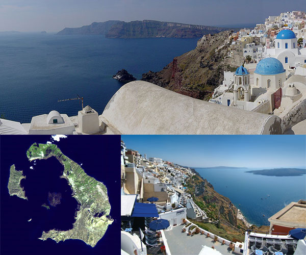
 Located in the South Aegean Sea, the island of Santorini, Greece, is the result of a gigantic volcanic eruption that left a giant caldera at its edge when the land collapsed. This huge lagoon, surrounded on three sides by thousand foot high cliffs, is over thirteen hundred feet deep. Atop the cliffs sits Santorini’s capital city, Fira, filled with charming white-washed cottages along narrow streets lined with jewelry, souvenir shops and cafes. The deep caldera can accommodate all but the largest ships, which can anchor just about anywhere in it, with the principal port being Athinias. Santorini is the largest island in the small Santorini archipelago, which is made up of inhabited Santorini and Therasia and uninhabited Nea Kameni, Palaia Kameni, Aspronisi and Christiana. Santorini, Greece, also known as Thera, and Therasia, were once part of the same island. They became separated by one of the largest catastrophic volcanic eruptions on Earth that occurred in the middle of the Second Millenium, in the Late Bronze Age.
The eruption destroyed Santorini and settlements on the nearby islands. It has been said that Plato wrote about the legendary island of Atlantis because he was inspired by that volcanic event on Thera. The volcanic explosion left a layer of ash, volcanic cinders and volcanic blocks or rock fragments two hundred feet thick on the island. The delineation of this white layer and the soil can be clearly seen today. Deposits of pumice from the eruption were found in sea beds and lakes as far away as Turkey. The eruption is said to have caused climate change in the area of the Mediterranean, the Aegean and even in the Northern Hemisphere. Evidence in studies of tree-ring dating, the dating science based on an analysis of tree ring patterns, shows that this climatic event depressed growth of Ireland’s European oak trees and Sweden’s Scotch pine trees. Crops failed in China due to a volcanic winter that is said to have been was caused by the eruption.
Today Santorini, Greece is a popular international tourist destination, mostly due to its charm and the beauty of its legendary sunsets and magnificent landscapes. Last year it was chosen by both the BBC and “Travel & Leisure Magazine” as the top island in the world. The summer months are most popular for visitors to the island. Spectacular sunsets can be viewed in the Oia Village at the island’s northern tip, which has an interrupted view. The island also has unique and fantastic beaches with a variety of colors of beach pebbles. The color depends on the solidified lava that is found on the beach, with red, black or white beaches. Most visitors consider Perissa Beach the best on the island. It is shielded by cliffs and very long with dark sand. The darker colored beaches have warmer waters due to the heat absorption process. The next most preferred beach is the one in Kamari, which is the black pebble beach. Above Kamari is Thera’s ancient city which is open from 10 am to 2:30 pm each day but Monday.
There are many villages on Santorini, Greece. Some have imposing old homes, or remnants of a Venetian castle, and there are several Byzantine churches on the island. The churches have bright blue domes and several of the villages spill picturesquely down the cliffs toward the caldera. Fira has a great many shops, tavernas and hotels. It is overlooking the port where most of the cruise ships anchor. Visitors can take a cable car up the cliffs, or go by mule up the almost six hundred steps. It is worth the trip, as it one of the most stunning villages on the island. Here you will also be able to visit the Museum of Prehistoric Thera, which displays artifacts found in the ruins. In the south of the island is Akrotiri, a thirty-five hundred year old Minoan town preserved in ash similar to Pompeii. It has well preserved streets, buildings and stairways. Wine-making is still an occupation on Santorini, Greece, so make a visit to one of the wineries for a taste of the local wines.
Santorini has many types of accommodations on the island for those who want to stay over. There are varieties of hotels, villas, rooms and apartments for all budgets. Santorini, Greece can be visited by plane, boat or water. Most cruises to the islands of Greece include a stop at Santorini, docking at the port below the ancient Thera. There is a major airport on the island which is only about three miles from the downtown area. Olympic Air, Aegean Airlines and Athens Airways all service the island, along with several charter flights. Ferry boats arrive daily from Naxos, Paros, and Piraeus, and fast catamarans arrive daily from Ios, Naxos, Paros, Mykonos, Folegandros, Sifnos, Iraklio and Piraeus. If you are visiting Santorini, Greece for just one day, do try to get there before sunset so you can make sure to see that fantastic sight. Some boats arrive at night, and you will not realize that you are entering a remarkable harbor that was once the crater of an enormous volcano. Come visit and see these splendors for yourself.