Map of Wales

Map of Wales

We have finally added a political map of Wales. How can we be a site that claims to know things about the map of Europe and not have a map of Wales? Well finally we have rectified that situation.

Wales is one of the countries that make up the United Kingdom. Which of course is situated in Western Europe.

The 8 preserved counties of Wales were created in 1972 and the 22 single-tier principal areas were created in 1996.

Counties Principal Areas Area Population
Clwyd Conwy
Denbighshire
Flintshire
Wrexham
2,910 491,100
Dyfed Carmarthenshire
Ceredigion
Pembrokeshire
5,780 375,200
Gwent Blaenau Gwent
Caerphilly
Monmouthshire
Newport
Torfaen
1,553 560,500
Gwynedd Gwynedd
Isle of Anglesey
3,262 187,400
Mid Glamorgan Bridgend
Merthyr Tydfil
Rhondda Cynon Taf
781 423,200
Powys Powys 5,196 132,000
South Glamorgan Cardiff
Vale of Glamorgan
475 445,000
West Glamorgan Neath Port Talbot
Swansea
820 365,500

In the near future we will be bringing maps of all the counties of Wales and all the Principal areas.

UK Map

Hi friends, We have a new a updated for 2018 map of the United Kingdom (UK Map). Has much changed? No not really. The Orkney Islands are still in the same place and the Shetland Islands have not wandered off to the Americas. Internally the UK is basically the same although, there is still a chance that Scotland may separate from England due to this Brexit fiasco. If that does happen we will be rushing out a new map of the UK as soon as the dust settles.

What does this map offer that previous UK maps didn’t? This map is much larger and all the big cities and counties marked. Counties like Northumberland, Cumbria and Strathclyde. We have plans on adding maps of all these counties to mapofeurope.com.

This map also highlights the large motorways and railway routes that cross the United Kingdom. So it is a good travel companion for those tourists who are lucky enough to be exploring the UK.

World Cup 2018 Russia – Map of Cities with Venues.

List of World Cup 2018 Russia, Host Cities and Venues

Here we have a map of the host cities in Russia for the World Cup 2018. Below we have a list of the cities and the stadium names with the capacity of the stadium listed. The only city that has 2 stadiums hosting world cup events is Moscow. The two stadiums in question are Spartak Stadium and Luzhniki Stadium. Luzhniki Stadium is a monster and is Russia’s largest capacity stadium.

  • Moscow –
    • Spartak Stadium (capacity: 45,360)
    • Luzhiniki Stadium (capacity: 81,000)
  • St. Peterberg
    • Krestovsky Stadium (capacity: 64,287)
  • Kaliningrad
    • Kaliningrad Stadium (capacity: 35,000)
  • Nizhny Novgorod
    • Nizhny Novgorod Stadium (capacity: 45,000)
  • Kazan
    • Kazan Arena (capacity: 45,379)
  • Yekaterinburg
    • Yekaterinburg Stadium (capacity: 35,000)
  • Saransk
    • Modovia Arena (capacity: 44,442)
  • Samara
    • Cosmos Arena (capacity: 44,918)
  • Volgograd
    • Volgograd Arena (capacity: 45,568)
  • Rostov
    • Rostov Arena (capacity: 45,000)
  • Sochi
    • Fisht Stadium (capacity: 47,659)

Map Of Income Inequality Across Europe

We collated income inequality stats into a graph and a map of Europe. This highlights which countries have income inequality issues. Not all European countries have been included. Notables like Russia did not have the data available as of time of publishing.

The formula that is used to derive the results in this article is “Income quintile share ratio”. This is the ratio of total income received by the 20 % of the population with the highest income (top quintile) to that received by the 20 % of the population with the lowest income (lowest quintile). Income must be understood as equivalised disposable income.
maybe swap the map and the graph i make the graph the featured image.

Bar Graph of Income Inequality Across Europe 2016-2017

Income inequality graph across Europe 2018

The above graph and map is based on the table below.

Table of Income Inequality Across European Countries.

Country 2016 2017
Iceland 3.4 3.3
Czech Republic 3.5 3.5
Slovenia 3.6 3.6
Slovakia 3.5 3.6
Finland 3.6 3.6
Norway 3.5 3.7
Belgium 3.8 3.8
Netherlands 3.8 3.9
Denmark 4.1 4.1
Austria 4 4.1
Malta 4.2 4.2
France 4.3 4.3
Hungary 4.3 4.3
Sweden 4.1 4.3
Ireland 4.5 4.4
Switzerland 4.5 4.4
Germany 4.8 4.6
Poland 4.9 4.8
Cyprus 5.2 4.9
Croatia 5.2 5
Luxembourg 4.3 5
United Kingdom 5.2 5.1
Estonia 6.2 5.6
Portugal 6 5.9
Latvia 6.5 6.2
Italy 5.8 6.3
Greece 6.5 6.6
Spain 6.9 6.6
Macedonia 6.6 6.6
Lithuania 7.5 7.1
Romania 8.3 7.2
Bulgaria 7.1 7.9
Serbia 9 9.7


Thanks to Eurostats for compiling these numbers.

Top 40 European Economies By GDP 2018

Top 40 European Economies 2018

Here we have a table of the top 40 European countries ranked by Gross Domestic Product. This doesn’t only include European Union Countries but all the countries that are considered part of the continent of Europe.

Some interesting takeaways from this years European GDP figures are the following:

  • Romania went up one place to become the 16th largest economy in the European Union (EU) in 2017. In the full list of countries that are considered part of Europe it is at 19th place.
  • Russia is still going backwards but that doesn’t seem to be affecting president Putin’s popularity. he won the election easily.
  • The Czech Republic is still growing strong, it also surpassed Greece in 2017 but this was largely expected unlike Romania.
  • Balkan countries like Croatia that have been hit rather hard in the last few years seem to be on their way to recovery.
2018 Rank Country 2011 2012 2013 2014 2015 2016 2017 2018
1st  Germany 3,761.142 3,545.946 3,753.687 3,885.440 3,365.293 3,494.898 3,684.816 4,211.635
2nd  United Kingdom 2,611.108 2,655.458 2,721.489 2,945.394 2,858.482 2,649.893 2,624.529 2,936.286
3rd  France 2,865.304 2,682.900 2,809.390 2,843.673 2,420.163 2,488.284 2,583.560 2,925.096
4th  Italy 2,278.376 2,073.972 2,130.997 2,141.937 1,815.759 1,858.913 1,937.894 2,181.970
5th  Russia 2,031.768 2,170.145 2,230.624 2,030.973 1,326.016 1,267.754 1,527.469 1,719.900
6th  Spain 1,489.381 1,340.689 1,369.690 1,383.537 1,199.715 1,252.163 1,313.951 1,506.439
7th  Netherlands 894.576 829.406 866.951 881.033 750.696 769.930 825.745 945.327
8th   Switzerland 696.528 665.898 685.871 712.050 664.603 651.770 678.575 741.688
9th  Poland 524.104 496.687 526.031 546.644 474.893 473.501 524.886 614.190
10th  Sweden 563.110 543.881 579.526 570.137 492.618 512.748 538.575 600.771
11th  Belgium 528.721 499.129 524.970 534.672 454.687 465.248 494.733 562.229
12th  Austria 429.493 407.801 428.456 437.123 374.124 387.299 416.845 477.672
13th  Norway 498.157 509.705 522.349 500.244 389.482 366.873 396.457 443.252
14th  Ireland 237.990 222.089 232.150 246.438 238.031 254.596 333.994 385.142
15th  Denmark 341.498 322.277 335.878 340.806 294.951 301.784 324.484 369.760
16th  Finland 273.925 256.849 268.281 271.165 229.671 234.578 253.244 289.557
17th  Czech Republic 227.307 206.751 208.796 205.658 181.858 185.269 213.189 251.577
18th  Portugal 245.120 216.488 224.983 230.012 199.077 205.085 218.064 248.891
19th  Romania 186.113 172.041 191.598 199.950 177.315 181.944 211.315 245.590
20th  Greece 289.068 249.663 242.306 238.023 195.320 194.594 200.690 226.774
21st  Hungary 139.447 126.825 133.424 137.104 120.636 117.729 132.034 163.541
22nd  Ukraine 163.307 175.707 179.572 130.660 90.524 83.550 109.321 119.134
23rd  Slovakia 97.621 92.799 97.743 99.971 86.629 89.797 95.938 111.483
24th  Luxembourg 59.010 56.323 60.150 62.395 57.423 60.176 62.393 72.461
25th  Bulgaria 55.799 52.613 54.517 55.837 48.957 49.364 56.943 64.781
26th  Croatia 62.172 56.484 57.849 57.159 48.850 49.928 54.516 61.056
27th  Belarus 59.735 63.615 71.710 76.139 54.609 45.887 54.436 59.246
28th  Slovenia 51.299 46.288 48.005 49.506 42.768 43.791 48.868 56.933
29th  Lithuania 43.478 42.828 46.426 48.232 41.267 43.024 47.263 54.352
30th  Serbia 46.488 40.749 45.520 43.866 36.513 37.381 41.471 48.279
31st  Latvia 28.488 28.343 30.838 31.970 27.048 28.177 30.319 35.915
32nd  Estonia 22.824 22.673 24.888 25.953 22.704 23.476 25.973 30.821
33rd  Iceland 14.666 14.183 15.330 16.693 16.718 18.633 23.909 29.109
34th  Bosnia and Herzegovina 18.318 16.906 17.852 17.977 15.794 16.324 18.058 20.340
35th  Albania 12.891 12.345 12.916 13.262 11.543 12.269 13.181 15.289
36th  Malta 9.604 9.289 10.056 10.582 9.801 10.341 12.543 14.873
37th  Macedonia 10.659 9.751 10.774 11.342 9.922 10.424 11.366 13.085
38th  Moldova 7.018 7.283 7.985 7.944 6.414 6.084 8.085 9.202
39th  Montenegro 4.500 4.048 4.419 4.462 4.039 4.182 4.764 5.547
40th  San Marino 2.056 1.802 1.802 1.786 1.566 1.569 1.636 1.809

Europe Map of National Dishes

Map of the National Dishes of European Countries

Here we have a Europe map with all the national dishes of the different countries listed. While lots of the dishes are endemic to certain countries. However this is not the whole story. Gastronomically speaking Europe would be better split up into food regions rather than countries. A good example would be the former Yugoslavia. It is now made up of many smaller countries like Croatia, Serbia, Bosnia and Herzegovina, Montenegro, Slovenia and Kosovo. This region has many dishes that almost all these countries would consider their own. These foods would be Burek, Cevapi (Cevapcici) , pita, pljeskavica and a whole lot seafood dishes. We have attributed these dishes to the countries that seemed to be the most vocal about a dish being theirs. We may not have got this right every time but we have tried to be as accurate as possible.

Above we have a map of the Dishes of Europe and below we have listed them in a table with the country listed beside it. We recommend as a fun trip trying to eat each national dish in the native country. Although you might need a few trips 😉

Country National Dish
Albania Kacamak
Austria Schnitzel
Belarus Draniki
Belgium Waffles
Bosnia and Herzegovina Burek
Bulgaria Banitsa
Croatia Cevapi
Czech Republic Svickova
Denmark Smorrebrod
Estonia Verivorst
Finland Mustikkapiirakka
France Foie Gras
Germany Wurst
Greece Moussaka
Hungary Goulash
Iceland Skyr
Ireland Irish Stew
Italy Pasta
Latvia Sklandrausis
Lithuania Cepelinai
Macedonia Tavche Gravche
Moldova Mamaliga
Montenegro Kacamak
Netherlands Herring
Norway Salmon
Poland Pierogi
Portugal Bacalhan
Romania Ciorba
Russia Pelmeni
Scotland Haggis
Serbia Burek
Slovakia Hulusky
Slovenia Gibenica
Spain Paella
Sweden Kottbullar
Switzerland Fondue
Ukraine Borshch
United Kingdom Fish & Chips

Map of Armenia

A map of Armenia

Armenia is considered to be on the very edge of what we would call modern day Europe. Some experts would say it is part of Asia Minor but one thing we know is that it definitely is a country that spans the east/west divide. The capital of Armenia is Yerevan with a population of about 1 million people as of 2018.

Here we have a large map and you can expand it to it’s maximum size by clicking on the image and then clicking on the cross in the top right hand corner.

Map of Roman Cities and Roads in Ancient Britain

Iron age Britain was dominated by one form of man made structure, that being the Roman road. Arguably the two Roman walls: the Antonine wall and Hadrian’s wall looked more impressive to the naked eye and the garrisons that became towns like Lindum and Veronis held large groups of humanity. The Roman roads did more to change and open up ancient Britain to Roman domination than any other structure. Most of these roads were built between 43 and 410 AD.

Even to this day some of the Roman roads are still in use in great Britain. Although upgraded and mostly covered by bitumen they are still there and are perfectly serviceable millennia later.

German Election Map 2017

German election map for the 2017 election

Here we have the German electoral results by region for the 2017 German election. It is as of  September 24, 2017 and the results are by no means final. What we do know already is that Angela Merkel has won a fourth term but AfD makes gains. Angela Merkel ‘s party the CSU has dropped from 49% to 38% in Bavaria. This is the worst result since 1949.

This election appears to be a crossroad for the CSU and the SPD (Social Democrats). Both parties have had historically low results with the AfD (Alternative for Germany) party making big gains. The AfD is a far right wing anti-immigration party and is the first far right party to join the German parliament in decades. With a 13.1 percent result it appears that the AfD will be a force to be reckoned with in the years to come and may even have a role in the upcoming coalition.

The SPD’s deputy leader (Manuela Schwesig) announced soon after the exit poll results

“For us, the grand coalition ends today”

and

For us it’s clear that we’ll go into opposition as demanded by the voter.

With the APD announcing that they are going into opposition, Merkel’s main option to form a coalition is to join with the Free Democrats (FDP) and the Greens. The FDP received approximately 10.1% and the greens received about 8.9% of the vote at this point in time. This coalition is colloquially known as the Jamaica coalition due to the colors of the parties involved making up the colors of the Jamaican flag.

The above 2017 German election map is based on exit polls and some counting of votes. It is likely to change in the next few days but not by much so we now go into a period of negotiations with Angela Merkel and her party trying to fuse together a working coalition.

Eurail Map

Eurail Map

Eurail Map or also known as Euro Rail Map

Here we have a huge Eurail Map of train lines that cross Europe. We have a list of the destinations and an indication of the path that the trains take. We have kept the map large so you can make out the names of the towns/destinations. If you are using a mobile phone to view it, you may have to scroll around to find the particular train station or train route you are interested in.

The best way to use this train network is to get yourself a Eurail Pass. Eurail passes are eaily the cheapest way to travel the European train network, especially if you plan on making many trips during your holiday. Go here if you want a simpler rail map of Europe.

Map of Georgia

Map of Georgia

Map of Georgia

Georgia is a small country of a about 4 million people as of 2017. Situated at the most eastern end of Europe, on the shores of the Black Sea. In Ancient times it was a key point on the famous Silk Road and possibly where Jason and the Argonauts found the Golden fleece.

During the Soviet years it became a backwater and was little considered by the west other than for the Soviet navy bases stationed there. Although recently embroiled in hostilities with Russia, it has come out of this period with a strong sense of self and willingness to embrace the rest of the world. The people are friendly and hospitable. It is definitely a must see if you are touring the other countries in the area.

Map of Munich

Map of Munich

A simple road map of Munich.

When you travel Europe you to collect lots of help items, contacts and other paraphernalia. This is great this is what helps you remember your holidays and will also come in handy next time you go touring the great continent. One thing in particular that I collect when travelling are maps and I dont mean gps maps, I mean paper maps. The maps are of cities and countries and even continents and I mark the places I visited on them and they become memorabilia of my adventures. A paper map of Munich I have is one such thing and is one of my prized possessions and every time I look at it those memories come flooding back. So make sure you always have a real map on hand to document your travels.


Pokemon Go Regional Exclusives Map

Pokemon Go Regional Exclusives Map

Pokemon Go has swept the world by storm. We here at Map of Europe all play the game. In pokemon Go there are pokemon that can only be found in certain regions. These are called regional exclusives and here we have a map that will help Pokemon Go traveler work out what regional exclusive is likely to be caught in the area that they are in.

The 6 regional exclusive pokemon are as follows:

  • Tauros – found in North America, mostly in the USA.
  • Heracross – Found in South America, although it can be found in southern parts of the USA like Florida.
  • Mr Mime – Found in Western and Central Europe.
  • Kangaskan – Found in Australasia, mainly in Australia.
  • Farfetch’d – Found in East Asia. Countries like Japan, North and South Korea.
  • Corsola _ This pokemon is interesting as far as we can tell it is found in a band that stretches across the whole globe. The band is roughly between between the latitudes of 31 North and 26 South.

So there you go Pokemon Trainers, get out there and catch those rare Pokemon.


Same Sex Marriage Europe map

Europe map same sex marriage

What ever your take is on same sex marriage, this map shows has an interesting insight into the views of different countries in Europe. The legend ranges from dark blue countries that are extremely tolerant of the lesbian and gay right to marriage. Through Light blue countries that are somewhat tolerant, all the way through to red countries that have varying limits of intolerance towards gay marriage.

The map does not include Russia, which is known to be officially very gay intolerant.

Below we have named the countries and the relative tolerance level towards LBG marriage:

The Tolerant Countries (dark blue):
  • Iceland
  • Sweden
  • Norway
  • Finland
  • England
  • Scotland
  • Ireland
  • Portugal
  • Spain
  • France
  • Belgium
  • Netherlands
  • Denmark
The Relatively Tolerant Countries (light blue):
  • Germany
  • Switzerland
  • Italy
  • Lichtenstein
  • Austria
  • Czech Republic
  • Slovenia
  • Greece
  • Estonia
  • Northern Ireland
Intolerant Countries (red)
  • Poland
  • Belarus
  • Latvia
  • Lithuania
  • Slovakia
  • Ukraine
  • Romania
  • Serbia
  • Bulgaria


The status of Croatia and Hungary seems t e in flux at the moment. These two countries swing between being somewhat tolerant (light blue) and intolerant (red). this is represented by red and light blue stripes.

Map of Europe – Importance of Ancestry to the Country

Europe importance of ancestry to country

Here we have a map of Europe that shows the countries that most value local ancestry in the population all the way down to the countries that value it the least. the lowest appear to be Norway and Finland. The Baltic and Eastern Block countries seem to value it the most. Countries like Russia, Ukraine and Georgia. Controversially some people call this the racism map of Europe. technically this is not rue as a major sign of racism in a country tends to be the number neo-nazi groups. When you map the number of neo-nazis over a map of Europe it does not necessarily follow this map.

Europe Map – Geography, History, Travel Tips and Fun

Europe Map

Click on the Europe Map above to get a larger more detailed view

Map of Europe and information about the continent

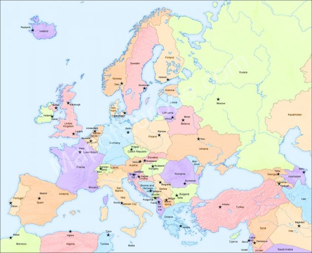
We have added a map that is probably our best and largest Europe Map. On Map of Europe we have termed our political map and although strictly it does not contain everything a political map should have it is close enough and is much easier to read than your standard Political map.

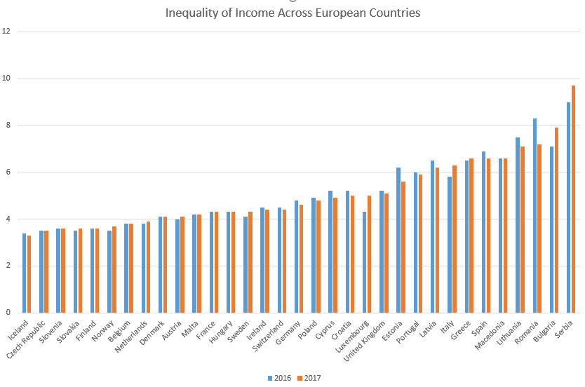
Europe is the sixth largest continent by land mass (approximately 3,997,929 square miles or 10,354,636 square km). Only one continent is smaller and that is Australia. The population is about 739,300,000 individuals, which makes it the world’s third most populated and it boasts some of the oldest civilizations of any continent.

Travelling Europe is one of life’s pleasures and due to the above mentioned civilization age, it boasts one of the oldest tourism industries also. Being so long established Europe caters well for every type of traveller.

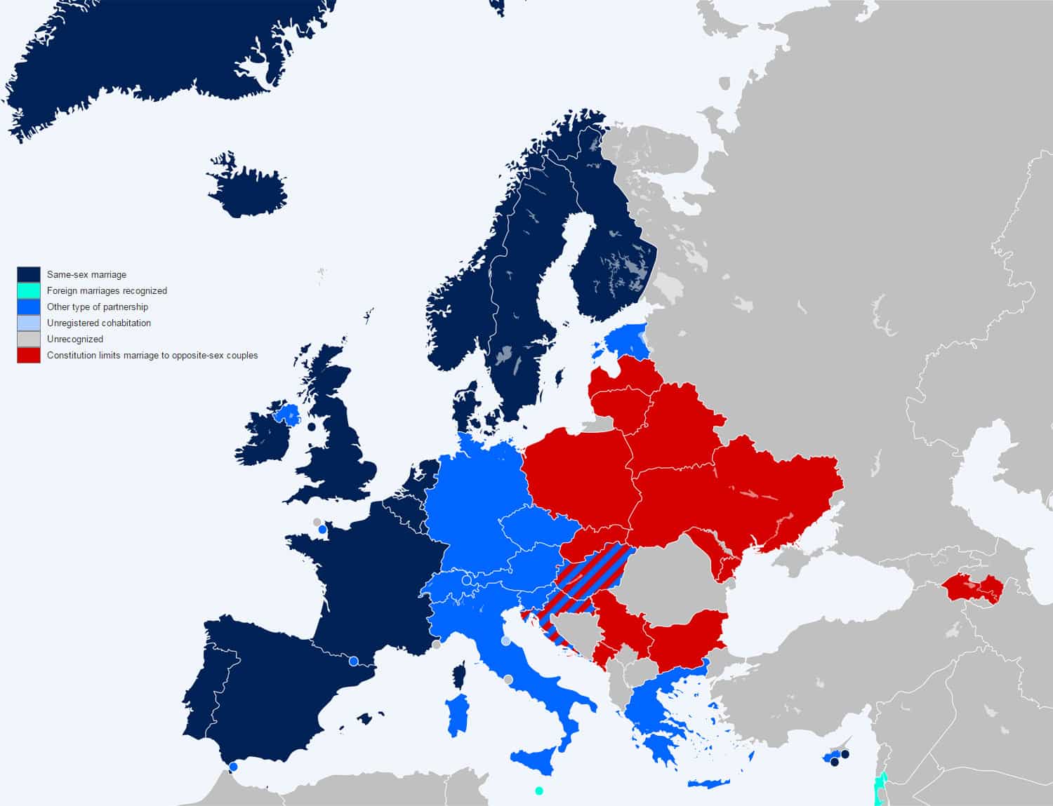
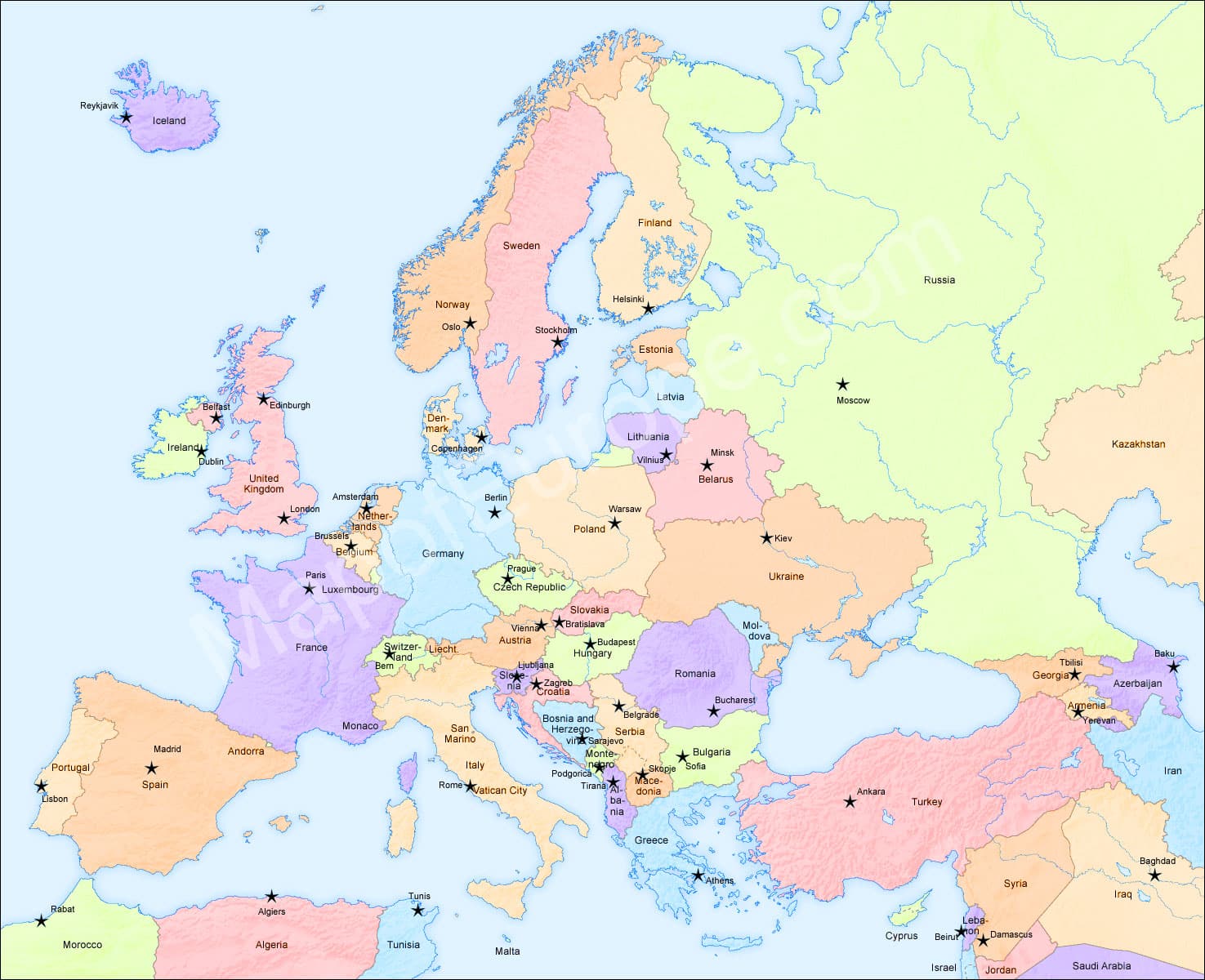
Europe is made up of 20 countries. The smallest is Vatican City, which is virtually only a suburb of Rome. The largest country is Russia, although if we are talking about Western Europe, then that would be France.

So if you are travelling a good map of Europe is necessary. We do live in a time of smart phones that have GPS functions but it is still a good idea to have a paper map of Europe as a backup. They fold up to be quite small, so every backpacker should have on one in her or his backpack. If you find yourself outside of signal range or if the battery in your GPS or phone empties, you still have a way of knowing where you are.

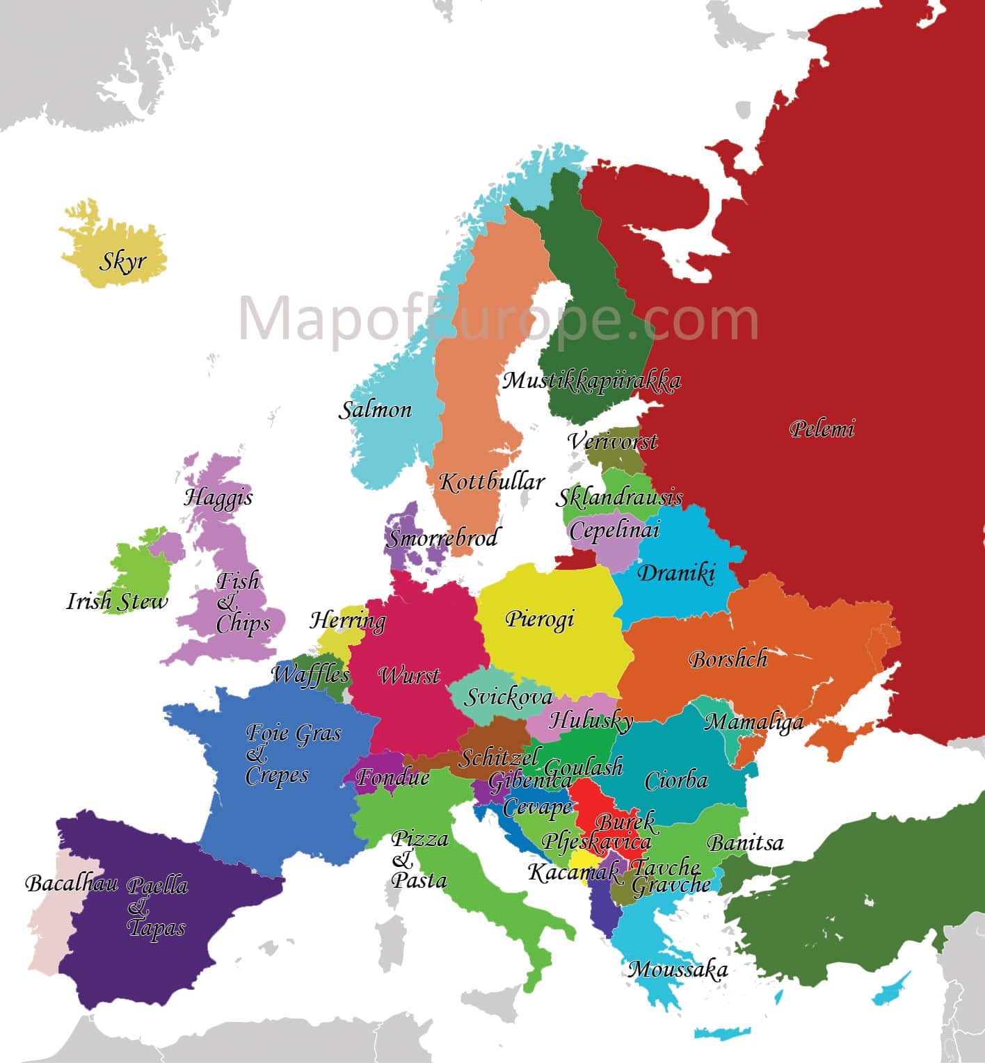
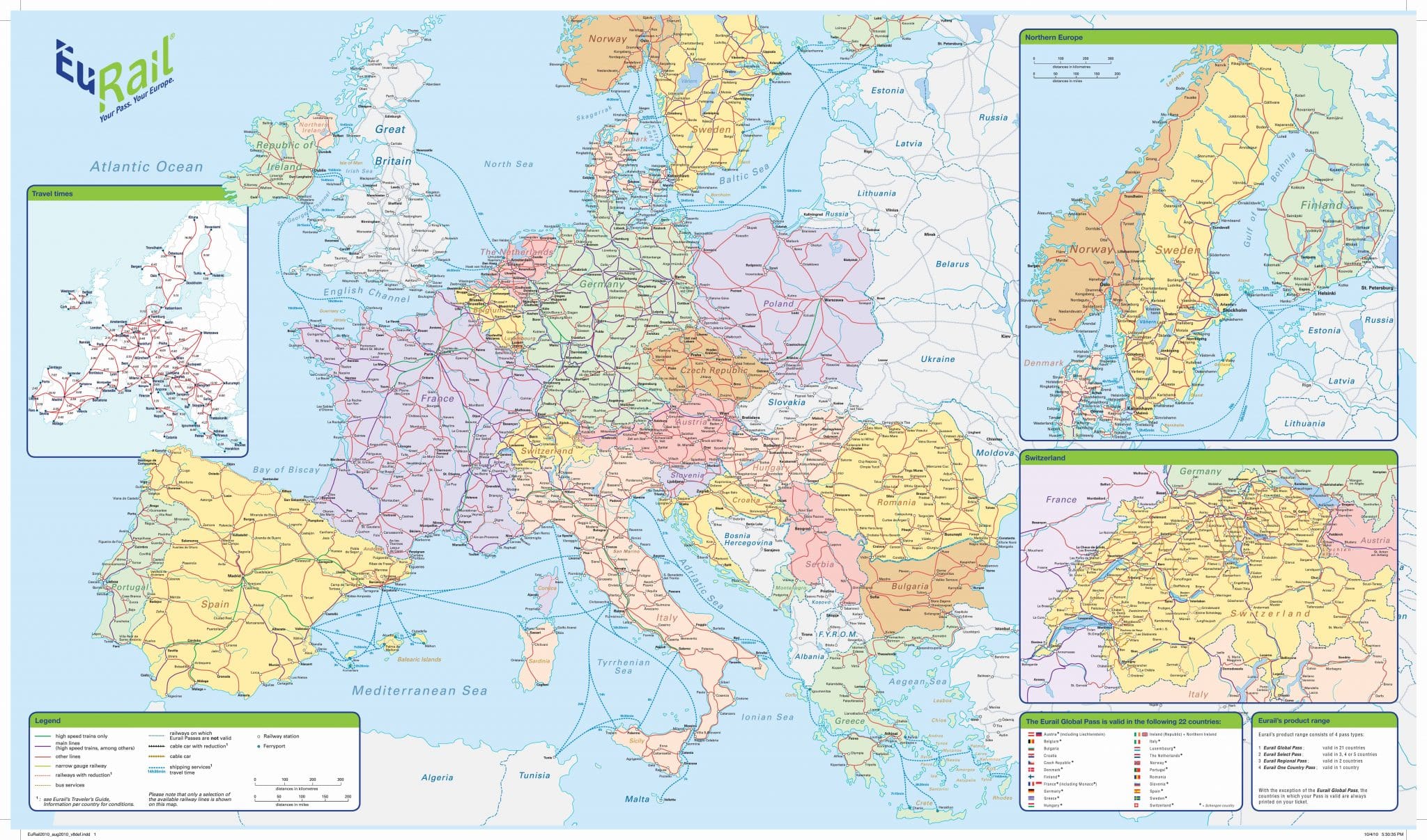
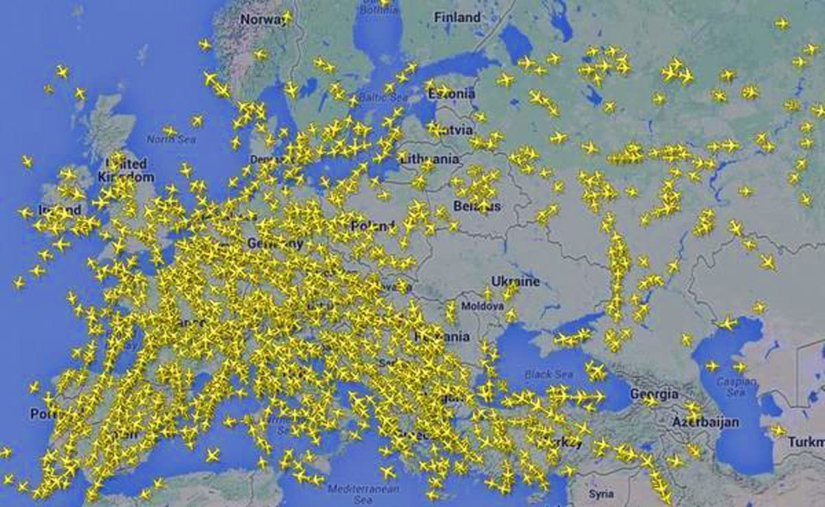
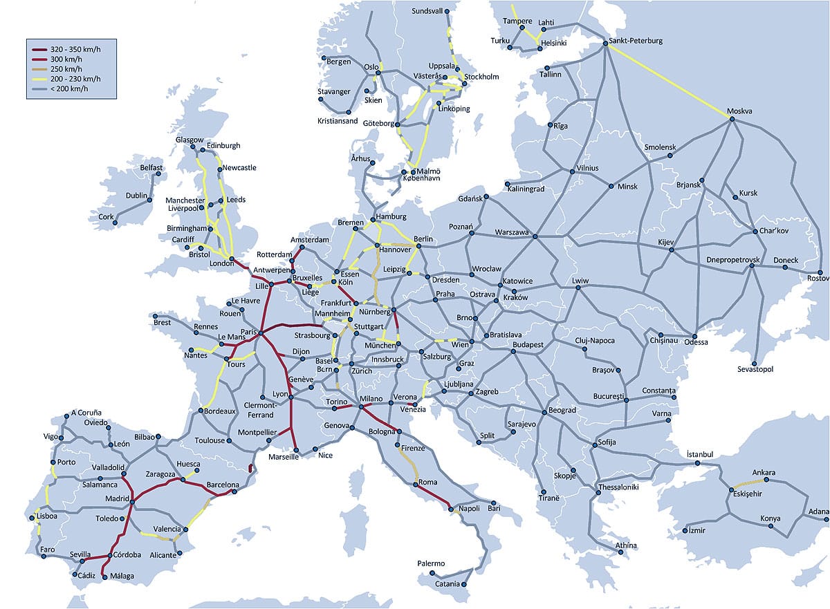
The diversity of cultures in Europe is one of the key reasons it is such a popular tourist destination. If you are looking for lazy summer beaches then Croatia, Greece, Spain and France are just some of the best hot spots for that type of travel. If Skiing is your thing then you might want to get out the maps of Switzerland, Austria, Germany, France and Slovenia. These countries have some of the best skiing in the world and some places you can ski all the year round. A good way to get to these ski fields is to travel by train as the train system in Europe is so good it is hardly affected by snow. buying a Eurail pass is the best way to go and here is a rail map of Europe to show you all the routes and destinations. We have also included a massive Eurail Map.

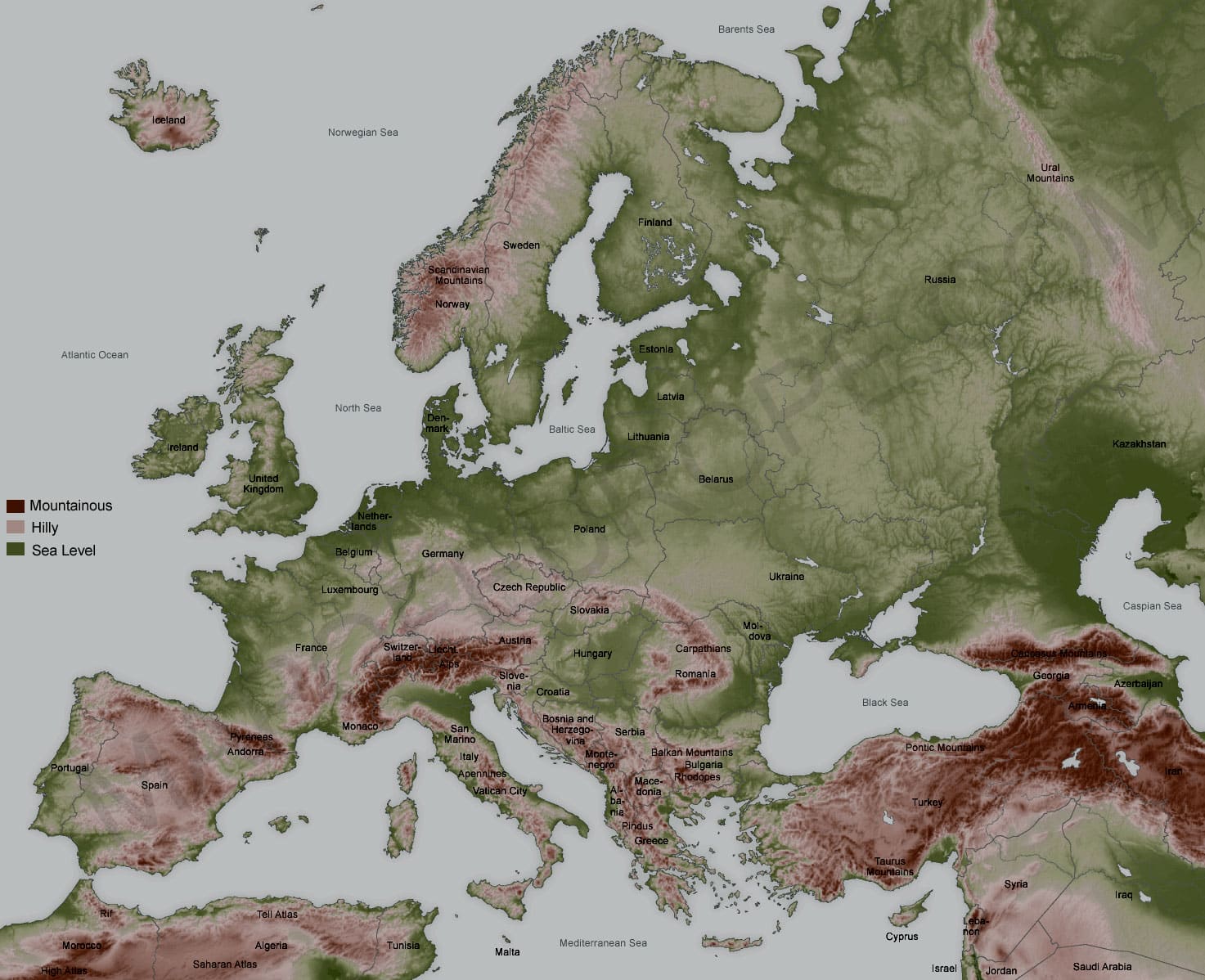
When looking at a topographic map of Europe you will notice that it is very mountainous and much of the wilder places are covered in arboreal forests. So if hiking is your thing then Europe is only quite willing to cater to your needs.

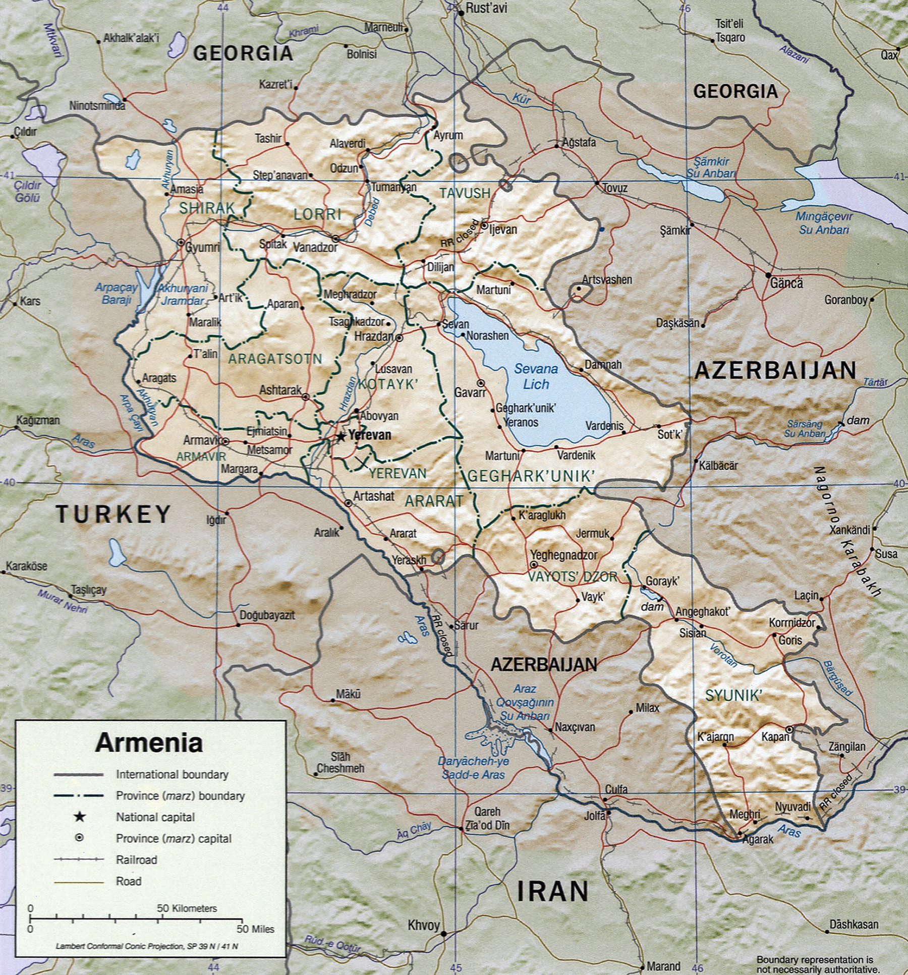
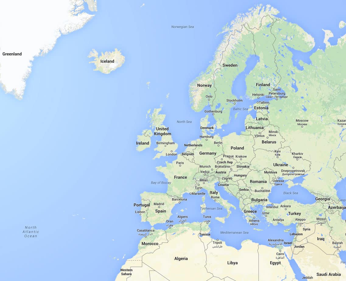
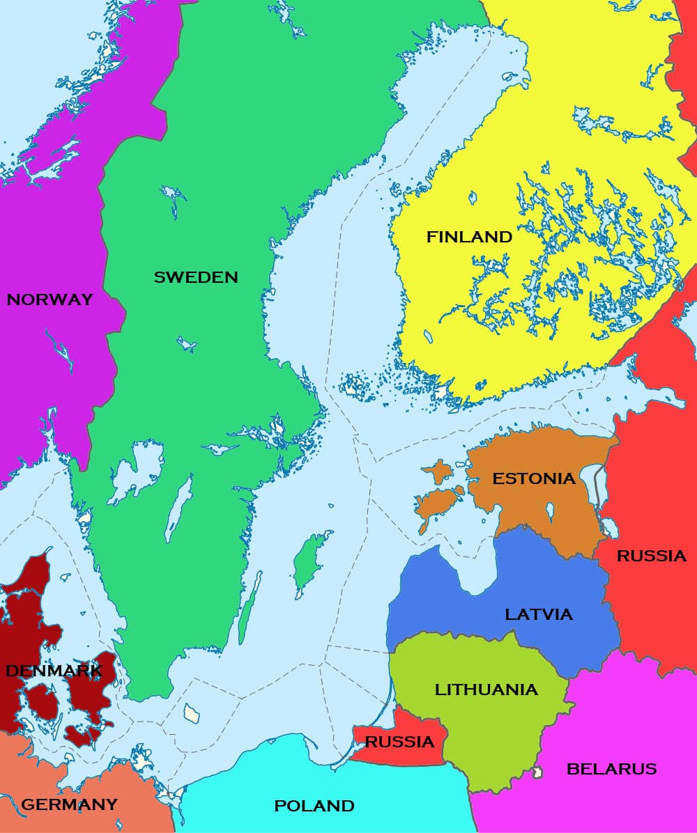
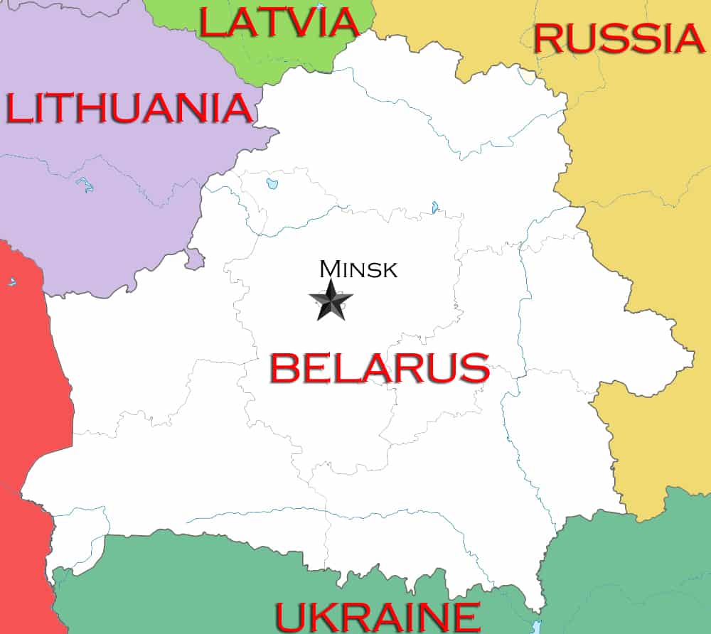
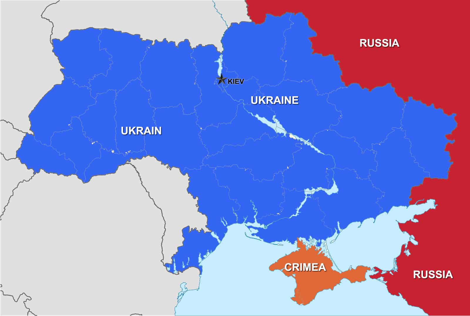
Some of the oceans and Seas that border the continent are as follows. The Barents Sea, Arctic Ocean and Norwegian Sea are to the north. The North Sea and Baltic Sea’s are more or less in the middle of the map. The Atlantic Ocean and the Greenland and Celtic Sea’s are off to the west of the continent. The Mediterranean, Adriatic and Aegean Sea’s lie to the south. The Black and Caspian Sea’s lie more or less to the east. Other naturally occurring borders are Ural Mountains and the Ural River and the Caucus Region (a group of countries, the best known of which are Armenia and Georgia).

Some Political information about Europe

There are about 50 countries that make up the continent of Europe. The largest being Russia and the smallest being Vatican City. Most countries in Europe belong to the European Union and use the Euro as currency. Click on the links below to learn more about each country.

Other physical features of the continent of Europe

The main rivers are the Danube, Rhine, Volga, Seine, Ural and Loire. The longest being the Danube. The main mountain ranges are The Alps, Pyrenees, Ural, Caucus and the Carpathian mountains. The highest mountain in Europe is situated in Russia and is called Mt Elbrus, it is 5642 meters high although the highest in Western Europe is Mt Blanc which is situated in France.

Map of Trees Per Square Kilometer in Europe

trees-per-square-km-europe

This great little map shows just how wooded the countries of Europe are. One of the general trends we can see is that the northern countries of Europe tend to have more trees. Although there are a few exceptions one being Portugal and some of the Baltic countries like Slovenia and Croatia.

The most heavily forested countries in Europe are Finland, Sweden and the aforementioned Slovenia. there are some notable mentions like Montenegro, Russia, Albania and Estonia.

As would be expected, Iceland has a very low concentration of trees. Due to it being a country of mostly volcanic activity, topped with ice and snow. The countries that are a bit of a surprise for having such a low tree population are England, Scotland, Whales and Ireland. When thinking of these countries you generally conjure up images of green countryside, although the green in this case must be hedges, plains and farmland.

Russian Ruble falls to lowest rate for 2014 against the US Dollar

Russian Ruble drops against the US dollar
Image from Yahoo Finance

With the Annexation of The Crimea and with Russia taking an active role in the war in the Ukraine, world opinion of Putin’s Russia has rarely been lower. This was highlighted when the West came together in March to enforce sanctions on Russia. Since then there have been another two rounds which seem to be having a quicker than expected constrictive affect on the Russian economy.

Today the Ruble dropped by 13% against the greenback and the day hasn’t finished. It is in fact the lowest it has been in five years. Oil prices are dropping again and as the Russian economy is linked to energy prices this slump has magnified the power of the sanctions. The fear that Russia would shut off the gas supply to Europe this year hasn’t seemed to eventuate and the speculation is that Russia can’t afford to carry out the threat without a massively detrimental affect on it’s own economy.

The other rumor is that a shady deal between Russia’s state owned Rosneft and the central bank that was supposed to fool the smart money, didn’t. The deal would allow Rosneft to refinance itself out of foreign bank debt and into Russian banks but this now looks like it has backfired.

With oil prices looking like they will be trending down and OPEC saying they expect low prices for a while as well as that they’re not afraid of $40 a barrel oil. Russia could be in a spot of bother as the economy seems to be geared for approximately $80 a barrel. Russian’s must be looking at Putin and wondering is he really worth all the bother? It looks like 2015 is going to be an interesting year on the world stage.

How do the Irish see the Map of Europe?

Irish map of europeOk this Map of Europe is just a bit of fun. One of our employees is an extremely proud Irishman and was talking about the St Patrick’s Day. it was mentioned that the whole world seemed to celebrate St Patrick’s day (a bit like the German Oktoberfest). Then he decided to show us how the Irish viewed the rest of Europe by making a special map for us. so without any further a adieu we present “how the Irish see the Map of Europe”.

Europe : Google Earth and Google Maps

Europe Google Maps
Click on map to enlarge
Europe Google Earth
Click on map to enlarge


Here at MapOfEurope.com we are big fans of Google Earth and Google Maps. While we like the static nature of our maps, especially for quick reference. We recognize that the interactive nature of both Google Earth and Google Maps can be at times invaluable. Recently we were looking at the map of Europe on both Google Earth and Google Maps and thought wouldn’t it be handy to have a static version of both. So we did just that, we took screenshots of the Google map and have uploaded them to the site. While they are not detailed maps, they are handy for a very quick reference. They show most of the relevant countries.

If this proves popular we will even do static maps of all the individual countries of Europe. We might even extend this to the rest of the world. So stay tuned. If there are any particular countries that you are interested in seeing in this format? let us know. We are happy to help.

Europe to sanction Sanction Rosneft, Gazprom Neft And Transneft.

Gazprom Rosneft TransneftFollowers of the Ukraine versus Russia war in Eastern Europe would be aware of the increase in rhetoric among NATO and other European nations, regarding the need for further sanctions against Russia. Europe watches will know that threats never extend to Russia’s big energy producing companies, Rosneft, Gazprom Neft And Transneft.  It appears this all about to change.

A marked escalation in the actions of Europe’s leaders is rumored to be unleashed this Friday the 12th of September 2014. You might want to mark this day in your diaries as it could end up being one of those days in history. If what Peter Spiegel tweeted is accurate then Europe and Russia are in for one very “interesting” winter. One that will be remembered for generations to come.

Peter Spiegel, the Brussels bureau chief of Financial Times has apparently seen a leaked copy of what is being proposed for the next round of sanctions for Russia over it’s involvement in the Ukraine war. Russia denies any involvement in the war but recent reports have Russian troops and combat vehicles actively participating in the fighting in Easter Ukraine. He tweeted:


This is an extremely bold move by the European heads. Winter is fast approaching and Russian gas has a major role to play in keeping Europe warm through those long cold European winter nights. It will also force Putin’s hand in having to announce retaliatory sanctions. This is not as easy at it seems, Russia relies on much of Europe’s food to keep it’s population fed during those even longer and colder Russian’ winter days and nights.

Ukraine War Map

Russian Attack on Ukraine 2022

Below we have an image showing where the initial attack by the aggressive Russian forces on the Ukraine in march 2022. Experts were expecting Russia to only attack the disputed regions of Donetsk and Luhansk. this appears to be incorrect information as the Russian forces have fired artillery shells all over the Ukraine.

Map of the Ukraine War

Above is a map of the contested regions within Ukraine as of August 2014. This is the second in a series of maps about the war in the Ukraine. The first being about the downing of flight MH13 and where it happened. While we hope that all issues are worked and that the fighting stops, if it doesn’t we will continue to publish updated maps of where the war has spread to. If indeed it does spread.

The Ukraine is subdivided into 24 Oblasts (provinces), most of which have not seen any fighting or unrest. The Oblasts that have seen unrest are as follows :

  • The mauve province is the Crimea, which has already been annexed by Russia and is considered Russian territory, although this situation has not been recognized by most of the nations of the UN.
  • The green provinces have seen pro-Russian protests but relatively little or no fighting. These provinces are Odessa, Mykolaiv, Kherson, Dnipropetrovsk and Zaporizhia.
  • The blue province is Kharkiv and this is a special region that has been occupied by the Regional State Administration or RSA. Effectively this equates to governor of Texas taking complete control of the state and not being beholden in anyway to Washington. This is a matter that still needs to be resolved.
  • The red provinces  of Donetsk and Luhansk are the ones that have seen the most intensive fighting. Thousands of people have been killed in these regions and there looks like no end to the hostilities, at least not in the near future. Donetsk is also the province that the ill-fated flight MH17 flying over when it was shot down by surface to air missiles.


Political Map of the Ukraine War and MH17 Crash Site

Political map of Ukrainian War and MH17 crash site

We have been inundated with requests to show how the Ukraine is split when it comes to Russian speakers and Ukrainian speakers.

So we have put together a political map of  the Ukraine showing the make up of Russian speaking population in the Eastern end of the country.

We have also shown where the flight MH17 was shot down. Most of the area currently in dispute, lies within the region of Donetsk. MH17 was shot down North East of the city of Torez that lies within this region.

The Crimea to the south has already been effectively annexed by Russia although this has not been recognized by any nations.

When looking at this map it begs the question. Why was flight MH17 even flying through that region? There has been intense fighting in the area and many other airlines have been avoiding the flight paths that pass through this war zone.

You will note that the Crimea and Donetsk are the two regions that have the highest Russian speaking population in the Ukraine and are effectively the only areas in dispute to date.

European Gas Pipeline Map and the Ukraine

European gas Pipeline Map and the Ukraine


There has been a spotlight shone on the Ukraine this week with the downing of flight MH17 by Ukrainian separatist rebels. However that war has been raging for quite a while now and the European Union has been very reluctant to get involved.

Why?

One theory is the reliance of the European community on Russian natural gas supplies as an energy supply. The Russian gas supply is particularly important in winter, as European household heating requirements increase.

The above map of gas pipelines  produced by Agence France-Presse shows the routes into Europe pass through the Ukraine. This adds a level of complexity to the diplomatic dance over the war in Ukraine. There used to be two parties that could interfere with European gas supply from Russia. The first party being the Russian government and associated government and corporate bodies (Gasprom), as happened back in 2009 . The second being the Ukrainian government. Although this possibility was considered almost negligible until recently as the Ukraine gathers a good commission by on-selling Russian gas.

Now we have a third player. The Russian backed separatist rebels in the east of Ukraine . These rebels seem to be backed by Russia and in fact it is considered highly likely that these rebels used a Russian built self propelled missile battery to down the ill fated flight MH17.


Why would the rebels want to interrupt the gas supply?

Currently there are two schools of thought on why the rebels would want to interrupt the European gas supply.

  1. By interrupting the winter gas supply the rebels could force the European community to put pressure on the Pro-west Ukrainian government to be less unyielding at the negotiating table.
  2. The other possibility is to force Russia to help more actively in the fight against the Ukrainian government. Currently it is widely believed that Russia is secretly helping the Ukrainian rebels. The added economic pressure on Russia  that slowing the gas supply would impose, might make Russia take steps to try and end the war earlier. Either by influencing the Ukrainian government or helping the rebels win the war.

In either case we can see that the winter of 2014-2015 is shaping up to be a tense one for European nations.


An amazing map of Europe showing aircraft getting out of Ukraine airspace

Ukraine airspace after Malaysian airliner was shot down

After the reported shooting down of Malaysian airliner (Flight MH17), it seems all air traffic was directed to leave or avoid Ukraine airspace. Above is an amazing image tweeted by NewsWeek. Sadly it would appear that all 295 people on board died as a result of this horrific  incident. Initial reports are that pro-Russian groups are the cause of this incident and are now hampering efforts by Ukrainian investigators to retrieve the black box flight recorded.

We will be updating this story as more information comes to light.


Some pictures of the crash zone are coming to light.


mh17-crash-pic

mh17 ukraine crash pic

Map of the Baltic Region

Baltic region and sea

The Baltic Region is Centered on the Baltic Sea

The Baltic Sea straddles the whole northern part of Europe. This narrow sea was where the early Vikings learned the fine art of sailing, amongst other things. In some places it is referred to as the Viking sea.

The countries that Surround it are as follows :

  • Norway    (Purple)
  • Sweden    (Green)
  • Finland     (Yellow)
  • Russia       (Red)
  • Estonia     (Brown)
  • Latvia       (Dark Blue)
  • Lithuania (Olive)
  • Poland      (Light Blue)
  • Germany  (
  • Denmark   (Red Brown)

While the above countries may border the Baltic Sea, other countries that are considered part of the Baltic region are :

  • Belarus (Pink)
  • to a lesser extent The Netherlands

You will note that Russia borders the Baltic Sea in two distinct and separate places.  There is a red region between Lithuania and Poland that is a part of Russia yet it is not physically connected to the main part of the Russian Federation.


The Baltic Sea flows into the North Sea which is adjacent to the UK.


Is Belarus Russia’s next target?

Proximity of Belarus to Russia

Will Russia invade Belarus next?

Now that Russia has effectively annexed The Crimea away from the Ukraine, we can start thinking about what country will be next. Vladimir Putin has stated on a number of occasions that he will take care of Russians no matter where they are found. Belarus has one of the largest Russian populations outside of Russia. Belarusian President Aleksandr Lukashenko is a hard line ruler of this small nation and has already expressed that what happened in the Ukraine will not be happening in Belarus.

Aleksandr harbors Russian sympathies, so things could go either way. Russia may move to bring Belarus under it’s wing, under the pretext of defending Belarus from outside/Western European influence or it could leaves things be. As Russia may feel that Regime in Belarus is strong enough to hold it’s own against outside influence.

Either way it will be a very tense time in Belarus over the next few weeks and months.

Map of European Undersea High Speed Cables

Europe's Underwater Optical Cable map

If you are a map buff like we are at Map of Europe dot com, then you should geta buzz out of Telegeography.com‘s latest research. They have put together some great maps of all of the planet’s high speed underwater telephony and data cables. We are showing you Europe’s here but they have many more and even have put together a great interactive website that shows the planet and how it is connected. We recommend you have a look at submarinecablemap.com

Ukraine, Crimea and Russia how close are they?

Distances between Ukraine, Crimea and Russia

With the possible conflict between Russia and The Ukraine over the Crimean peninsula. Map of Europe has decided to put up a large map of the region. so that you can get some sense of how close these nations are to each other.

If you feel there are some other maps that would be beneficial in explaining how these countries relate. Please do not hesitate to contact us. We are only to happy to help.

Topographical Map Of Europe

Topographical Map of Europe

A simple topographical Europe Map

Here we present a simple topographical map of Europe. The darker reds and browns are the higher and mountainous regions. The lighter brown and pink regions are the hilly regions and foothills of the mountains. The light green regions are the plains areas and the dark green areas are the sea level or close to sea level areas.

As you can see as you head East, Europe tends to get flatter and lower. The only exception to this are the Ural mountains, which blip up a little as we head into Russia proper. The highest regions are the Alps and the Pyrenese mountains. Although there are some regions in Bosnia-Herzegovina and in Bulgaria that are quite mountainous also.

Brussels

Brussels the capital of BelgiumIt is only fair that you take some time off after a busy season at work to re-energize and relax. This could be in the form of a much needed vacation where you get to spend your holidays away from home. This is could be at a tourist destination within your country or even away from your home country that would involve some travel. There are quite a number of cities around the globe that are known for their rich cultural and historical heritage hence are leading tourist destinations. One of these destinations is Brussels which is also the capital of Belgium. Generally Belgium is categorized among the leading tourist destinations in Europe that promises an out of this world experience as you get to explore the various attractions and engage in different relaxing and rewarding activities. Belgium boasts of dynamic cities like Antwerp as well as medieval architecture. Among the interesting places that tourists like to visit while in Belgium is the Royal Museum of Fine Arts that is endowed with a huge collection of painting dating back to the 14th century. Also notable is the famous Waterloo that saw the defeat of Napoleon by the then Duke of Wellington. This is one of the reasons that tourists come to explore Belgium.

Brussels offers diverse architecture that spans from the medieval age, with the main attraction being the Grand place, a UNESCO world heritage site and the Royal palace. Also notable is the Manneken Pis that is a bronze sculpture cum fountain of a urinating youth. Other notable attractions that prompt tourists to tour Belgium are the Flander battlefields and the Ypres War Memorials. This is mainly because of the link between the Ypres town and the First World War as it holds silent of those who died in the First World War. Besides, those who travel to Brussels get to experience the over three thousand castles. Three hundred of these castles are open to the public. However, it is the Gravensteen castle that is also referred to as Castle of the Counts which is most popular. Another place that you must not fail to visit is Town of Spa that offers relaxing fine waters and the Bruges commonly known as Venice of North because of the bridges and canals. For lovers of chocolate, Brussels offers the best of chocolate with an estimated over two thousand chocolate shops and a production of over 172,000 tons of the same. Children who travel to Brussels as part of their holidays need not to worry about getting bored as there are a number of carnivals and festivals every year. These include the Zinneke parade and the Ommegang festival among others. The other Belgium cities also hold the same for example the Carnival de Blinche that is held in Blinche and the Stavelot that is held in Mid-Lent Carnival.

Brussels is also a great shopping destination for those people who love shopping. The Flea market is famous for not only crockery but also vintage clothes, household items and furniture. Antique lovers can also be sure to find some of the best antiques in Europe in places like Place du Grand Sablon. If you are keen on fashion items you can also be sure to find shoes, accessories and clothes that are fashionable from a range of shops like the Brooklyn Antwerp or even the High and Mighty. Another great shop for shoppers is the Mier. In fact, people who like to go shopping often make Brussels and Belgium in general their tourist destination.

A tour of Brussels will be incomplete without an experience of the Belgium cuisine. In fact, Belgians believe that their food is prepared using French Finesse and served with the German generosity. The Belgian cuisine is famous for not only known for frites and mussels but also endive and waffles. Of important mention is the fact that the seafood and fish are as important as beer that is as popular as the Belgium brewing tradition. Also included in the Belgian cuisine are game birds, meat and potatoes. One of the famous types is the chicory or the Belgian endive. Street foods are also common for instance French fries that are usually served on paper cones alongside mayonnaise and curry sauce. It is believed that besides other attractions, the Belgian cuisine is among the reasons tourists flock into Belgium. There are numerous other places and attractions that cause tourists to travel to Brussels and the large Belgium. Because of the vast nature of the tourist attractions in Brussels, it is wise to research about the attractions and make up your mind on the places that you intend to visit before hand. This is not only good planning purposes but also helpful in managing the finances that you have set a side for your trip.

Rail Map Europe

A rail Europe map

Rail Europe tickets are a great alternative to flying. Imagine taking in the breath taking views of the European Alps, the Med, the Adriatic, the Greek Isles and much more. Travelling by train in today’s day age will allow you to have a proper holiday. It will allow you relax and reflect while you speed towards your destination in complete comfort and style. No worries about luggage size. Take all the gear for the whole family on that ski trip and not worry about excess baggage fees. No bookings are essential; you can purchase your ticket at any time. Turn up at the train station and start your holiday. No more worrying about flight schedules. If you miss one train! Catch the next!

The best way to buy a rail Europe ticket is get a Eurail Global Pass some people refer to them incorrectly as Eurorail Passes but it basically means the same thing. These can be bought as 10 day to 3 month passes. 3 month passes being the best value but of course are the most expensive as well. Have a look at the rail Europe map in the centre of the page and see if it the countries and cities you are interested in visiting for your vacation are included. They should be as most Western European countries are covered by these railway passes.

The rail systems that are covered by most train passes include.

  • Eurostar – is a high-speed passenger rail service connecting London with Paris and Brussels. All its trains traverse the Channel Tunnel between Britain and France, owned and operated separately by Euro-tunnel.
  • German rail (Deutsche bahn) – is the German national railway company. 3 different railway companies were merged to form this company. 1) Deutsche Reichsbahn of East Germany, 2) VdeR . it had railway assets in West Berlin, 3) Deutsche Bundesbahn of West Germany.
  • British Rail (British Railways) . Is an amalgamation of the .big four. 1) Great Western Railway, 2) London, Midland and Scottish Railway, 3) London and North Eastern Railway, 4) Southern Railway.
  • Swiss Federal Railways . Is the official railway of Switzerland.

How does it compare to a driving holiday? Well Driving can be fun but it can also be stressful. So depending on what kind of holiday you are looking for, will depend on what mode of transport you choose. Most train stations are at the heart of a European metropolis centre. So shopping, cafes, the art galleries and museums are usually not far away and usually within walking distance. The rising cost of fuel is starting to make an impact in both the airline industry and the driving holiday set. With a train the economies of scale mean that fuel has a smaller impact on price. A Europe rail pass is also so versatile. Extending holidays is no drama and adding locations to your holiday is as easy as turning up on a new train platform.

Travelling Europe by train is a great cheap alternative to flying. You will have more chances to meet like minded travellers and to take in the natural and urban beauty of Europe. Buying rail tickets in Europe is easy. You can get them over the internet or go to almost any railway station. So if you are thinking about travelling Europe by train make sure you do your research, you will be happy you did.  Oh and one more thing make sure you search online for a Rail Europe coupon code. It will make travelling the railways of Europe that much cheaper.

We have now added an updated rail Europe 2023 map.

Venice is unforgettable

Amazing Venice in Italy
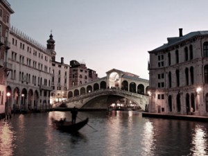
Venice is truly a beautiful and romantic city. Anyone who intends to visit this Italian city will enjoy the city’s beauty of nature especially the natural water canals. People are not only attracted to this ancient city because it was built on a lagoon but also because of its famous landmarks, beautiful old-fashion streets and rich culture. Remember, even in Shakespeare’s time this city was a famous trading city so popular in fact that the play writer could come up with the play The Merchant of Venice without even setting his feet on this ancient trading city or even having been to Italy.

Venice is a preferred city for any tourists especially newly wed. The reason why it is known to be a romantic city is simply because it is mostly visited by couples who want to have a romantic experience. It is common to find more tourists as compare to the local population of the city. It is also common to find tourists in a group of two enjoying every bit of the romantic experience Venice has to offer.

Tourist trade is the only source of income for the local people known as Venetians. When you visit Venice, you may think its buildings were built just to attract tourist. It is beautified by its narrow canals mounted by old and attractive bridges and buildings. Make sure get a good map of Venice when going to this lovely city.

Venice was built in the 5th Century and it later grew to a maritime empire. It comprises of 121 small islands connected by an incredible 435 bridges. The city stands on a lagoon making it the most popular experience for tourists. City streets clogged with polluting road traffic is a phenomenon that is never found in this city. The best way of moving around this city is by water using water buses. However, there are raised sidewalks which can be used to move from a certain point to another without getting your feet wet.

If you are planning to visit Venice, it is important to get yourself familiar with the map of the city’s vaporetto ways first.  They are usually found in most of the city’s guidebooks and also easily downloadable from the internet. It is a good idea to book a hotel of your choice before booking your flight to Venice so as to avoid missing out due to the large number of tourists the city receives throughout the year.

On the day of visit, the first decision you will have to take upon arrival at the city’s Marco Polo Airport is how to get to your reserved hotel. There is a walkway at the airport that leads to an area where you can see the city for the first time. To get to your hotel there are buses and taxis that can take you to your hotel by road, but by far the best way to travel is by water boats or vaporetti. These vaporetti will take you to your stop in an hour’s time. When you use these Alilaguna company vaporetti you will get to enjoy the magnificent old fashioned building and bridges of this ancient city. You can also use the water taxi if you want to save money since it can accommodate more people and thus the fare is cheaper compared to vaporetti.

You can take the red vaporetti route which goes around the attractive ancient island of Murano and on to Lido’s beaches then towards St. Mark’s Square which is a tourist hotspot. St. Mark’s Square is known as Piazza San Marko by the local population. It has the Campanile bell tower which is the tallest building in Venice. The top of the Campanile can be accessed via a lift; from there you can see the whole of the red roofed city. You can also find the Doge’s palace at the St. Mark’s Square. This palace is symbol of Venice judicial and political history and as far back as the 9th Century it was the city’s dukes’ seat of power. You can visit the private chambers, halls of state and even torture chambers.

Map of Venice
Map of Venice (Venezia)

St. Mark’s Square is connected to the Grand Canal by a group of shopping streets. Here you will get Murano glass made jewellery and Venetian traditional balls and ornaments. As you walk through these streets, you will get to another Venice’s famous landmark, the Rialto Bridge.

Venice is also blessed with magnificent art galleries. One fine gallery is the Galleria dell’Accademia. It is located on the quiet island of Dorsoduro. It has a rich Venice’s art.

The centre of Venice is easily accessible even on foot. You can walk around in less than an hour. However, the maze created by small canals is amazing; you can walk around and stop each time to take a photo due to the picturesque bridges and buildings around. You can enter a cafe and have an ice cream while watching water boats ferry tourists with the backdrop of picturesque view of buildings.

Memorable holiday by visiting Munich

Munich in GermanyIf one wants to make their holidays as memorable as they possibly can be, then it might be a good idea to consider the city of Munich in Germany as one of their destination.  This city boasts of being the third largest city in Germany with the average population of about one million three hundred and fifty thousand inhabitants. The city has a motto, which translates to Munich likes you. From the city motto, one gets a feel of what this city has to offer to the tourist.

The rich history of the city is something that is helping to attract people who want to explore Munich. The history of the city states that it was initially founded by monks thus the name that it has got is a derivative if the word that means by the monks place. This is just a sample of the rich history that this city has to offer to the travelling visitor. The modern city of Munich is now a financial hub spot that has got a thriving economy and a booming tourist industry. The infrastructure of this city is one of the best in the world and this means that the tourist will be able to enjoy the services of plush hotels and other amenities that this city has to offer. Holiday that is spent in Munich is guaranteed to be fun and relaxing and this is one of the reasons that this city has seen a rise in the number of tourist.

The city is modern and is a leader when it comes to the international field of technology innovation and financial growth. Some reviewers of cites have ranked it as the world most livable city. What this means is that the city is the crème of civilization and the quality of services and the quality of life in the city is among the highest in the world. Many people would love to simply go and live in this great city and the tourists who visit this city will feel that they need to revisit since the experience that they will have will be so good.

The history of the city and its establishment is rich and the tourist will be amazed at the important events that this city has hosted. There are various important landmarks that one can go and visit to get a sense of the rich diversity that this city has to offer. This city has been the host for great events that happened in the past and was at one time the spotlight of artistic and historical events in the past civilization. The history of this city is also tied to the history of the international community. Munich was an important player in the two world wars that ravaged the globe. It was greatly affected by the two wars just as Berlin was affected by the two world wars. The city’s ability to rebuild and emerge as one of the best cities in the world is something to marvel at. It is the reason that many people will visit Germany and Munich in particular. The tourist can see and understand how this city was affected, and how the inhabitants had to start rebuilding the city after the world wars.

The city was and still is the center of many political happenings and events that have changed the landscape ofGermanypolitics over the past centuries. It is an important element in the political happenings of Germany and has a say in the way Germany’s politics and other social economical issues are viewed and shaped.

Although the city was heavily damaged by the allied bombings during the war, it has been able to rebuild itself into an important city in the republicof Germany. This is due to the fact that the city has been able to attract investors and industries that have helped in the reconstruction process. The city now has a well-defined infrastructure that not only caters for the residents but can also support the huge number of tourists who come in every year. Most of the residents that now live in Munich enjoy a very high standard of living. This standard of living can be experienced by the visitor when they visit this great city.

The economy of Munich is driven by industrial and information technology developments. The crime rate that this city experiences is very low so the tourist is now able to enjoy romantic walks in the evening without having to worry about being mugged. No tourist will visit a city that has the highest crime rate in the world. Most people will shy away from such cities due to obvious risk factor that the visit to the city entails. Security is one of the most important issues that the tourist looks at when they are deciding the destination for their holiday. It is the reason that some cities will experience a high rate tourist while others will experiences a reduced number of tourists. Munich is a safe and secure city that one can tour and have a good time.

Amsterdam

Amsterdam the northern European Cosmopolitan metropolis

Amsterdam in HollandAmsterdam is known not just the capital of Netherlands but also the largest city. This city is endowed with about a hundred kilometres of canals, one thousand five hundred bridges and ninety islands that earned it the name Venice of the North. Amsterdam which is in the North Holland province is thus an excellent tourist and holidays destination especially for those people who would like to experience ancient history. In fact, it is among the most popular destinations for tourists in the larger Europe as it receives a huge number of visitors, estimated at 4.6 million, drawn from different parts of the world every year. There are numerous attractions that Amsterdam has to offer ranging from the historic canals to museums and the coffee shops. Also notable is the Amsterdam Stock Exchange which is the world’s oldest.

Some interesting information that visitors who tour Amsterdam appreciate is that the canals did not just happen but they were consciously planned for in the course of planning for the city at a time when the rate of immigration was too high. The planning mainly based on the canals concentric four half circles whose ends emerged at IJ bay. Three of these canals were mainly directed towards residential development. Ultimately though the canals were dedicated to ensuring defence, transport as well as water management. The canals offer scenic views into the beauty of Amsterdam thereby encouraging visitors to explore the city. The canals have since been included in the UNESCO world heritage list.

The other attractions that visitors and tourists get to experience while in Amsterdam include the numerous museums that are home to years of history. In fact, a visit to the museums is considered to be one of the best ways of reliving the history of Netherlands. One of the important museums that tourists must not fail to explore is Rijksmuseum that having been created towards the end of the 19th century. This museum which is also Netherland’s national museum is mainly dedicated crafts, arts as well as history. This is evident in the large collection of Dutch Golden Age paintings as well as the considerable Asian art collection. Originally founded in The Hague in 1800 with the aim of exhibiting Dutch Stadtholders collection, the museum was later to move to Amsterdam under the orders of king Louis Bonaparte. Visitors who travel to Amsterdam may also tour the other museums that include the Stedelijk museum whose specialty is modern art, Van Gogh museum that holds a lot of Vincent Van Gogh’s works and Rembrandt house museum among numerous others museums.

Besides museums, Amsterdam also offers a perfect environment for holidays as it houses De Wallen, an area that is set aside of prostitution that is legalized in its red light district. In fact, the red light district has become popular among tourists and has a well knit alleys and roads network that are rented out. Other attractions in Amsterdam include parks that are very common among people who not only want to experience Amsterdam but also want to enjoy a great family moment at picnics. The parks offer a serene environment that is characterized by water fountains, open fresh air as well as the sun. Additionally, depending on the time of the year that you will travel to Amsterdam, you may engage in festivals like the Qeens’ or Koninginnedag day that have music concerts organized, opera, children’s games among other activities.

In order to ensure that your experience in Amsterdam is worth remembering, you will need to be aware of the best time of the year to travel. For instance in order to have the best of the canals, you will need to be in Amsterdam in the months between April and October during maritime climate. However, the high season runs from April all the way to December while October and November and also January to March are low seasons for tourists. Accommodation is not a matter of concern as there are numerous hotels of different calibres which you can check in. there are also hostels as well as camping sites. Amsterdam is also a great city for shopping as it is dotted with numerous department stores as well as specialty shops. The Cornelis and Pieter Cornelisz Hooftstraat are streets that are usually busy with shoppers. Amsterdam is also home to fashion brands such as G-star, Blue Blood, Gsus as well as Iris van Herpen among others. In fact, it also houses a garment centre at the World Fashion Centre with most of the buildings that were previously used as brothels within the red light district being turned into ateliers for upcoming fashion designers. In conclusion, a trip to Amsterdam for holidays or even as a tourist promises a lot of fun and insight into the history of the city.

Paris

Paris – the romantic jewel of Europe

Paris the capital of France
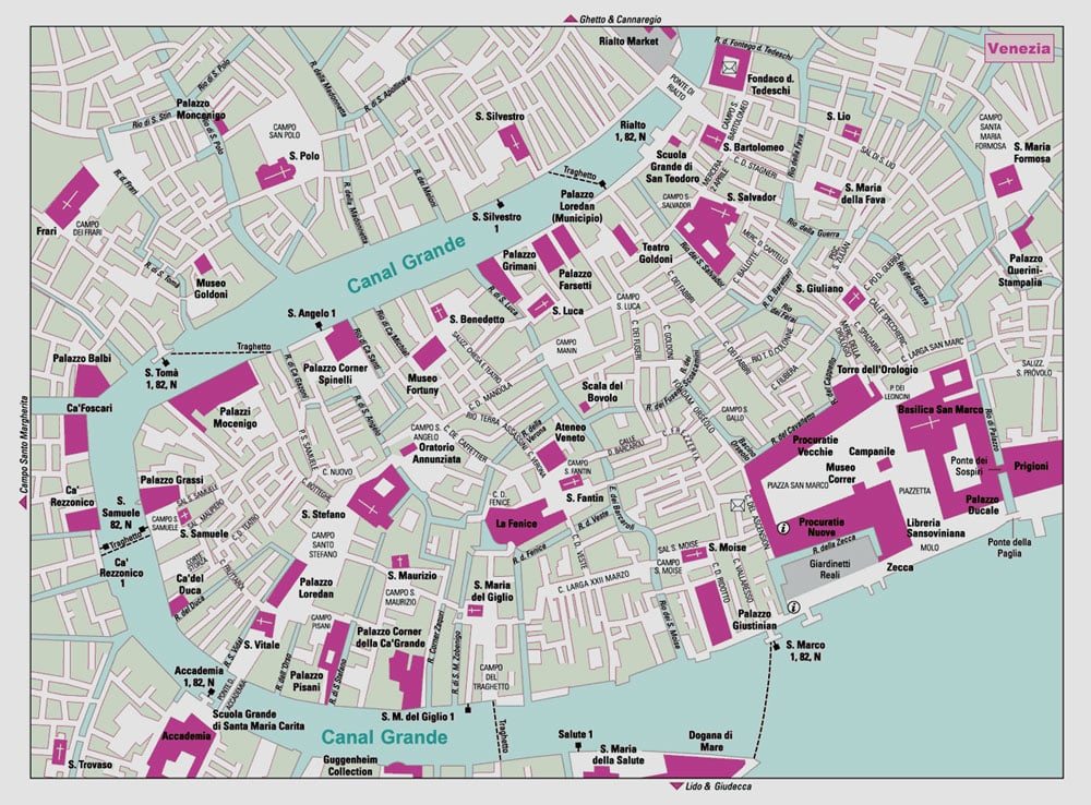
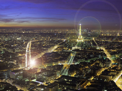
A visit to France will be incomplete without alluring the captivating beauty of Paris, also regarded as the city of light. This city offers an amazing experience of the French culture as well as the rich history of France. Paris which is known as to be the most romantic city in the world boasts of a combination of both the old charm of the world with contemporary culture making it an enchanting and intriguing destination for vacations. While in this city visitors get to explore the more than two hundred museums and galleries, hidden treasures, famous attractions, romantic restaurants and chic café all of which offer something for everyone.

Paris is not just the capital of France but also one of the most popular tourist destinations in the world having been ranked third after New York City and Orlando. The city is estimated to receive close to 42 million visitors. It is also ranked first with regards to international tourist arrivals with the number estimated at 17 million visitors. The city as well as its region is known for a number of historical monuments that are key tourist attractions with four of these having been listed among the UNESCO world heritage sites. This is enough evidence that Paris is a great city to tour not just as a tourist but also for holidays for an experience that is unforgettable.  Some of the popular attractions in Paris include Basilique du Sacre Coeur, the Lourve, Notre Dame de Paris, the Eiffel Tower, Arc de Triompe and Champs-Elysees and Musee d’Orsay.

The other famous attraction in Paris is the Notre Dame de Paris that means Our Lady of Paris. The cathedral is synonymous with French Gothic architecture that is, stained glass windows that are beautiful as well as dramatic spires and towers. Moreover, it has regained ill repute for being home to Disney’s Hunchback. What captivates visitors most is the intricate art, a magnificent panoramic view of Paris as well stone gargoyles. The Notre Dame Cathedral is said to have been completed over a period of close to two hundred years.

Another attraction  that you cannot miss to see include the Louver, that guarantees you travel through ages as you get to explore antiquities and art work that dates back to centuries ago by walking into one of the few museums in the world that is not only the largest and oldest but also fascinating. This museum which was at one time a royal palace is a historical landmark that houses a number of not just amazing but also acclaimed proof of brilliance in art like Mona Lisa by Da Vinci, Dying slave by Michelangelo as well as Venus de Milo, a famed Greek sculpture. The Louvre also presents an opportunity to tour Mesopotamia in ancient Egypt and the middle ages and also experience the awakening of Italian Renaissance expressed through art. Other attractions worth exploring at the Louvre include the Ottoman period as well as various styles that are representative of the French Revolution. The Louvre presents an opportunity to listen to history speak strength, perseverance and love as seen through ages.

The other place in Paris that is worth visiting is the Champs-Elysees and Arc de Triomphe. This is especially ideal for people who consider relaxed holidays as they can stroll through these undoubtedly beautiful and glamorous avenues. Movie lovers may also consider enjoying popping in at the cinema or the specialty shops and end up at the café for rich delicacies. Visitors are usually advised to take time in order to make the most of what Champs-Elysees offers before ending the tour with Arc de Triomphe an architectural piece crowning crossroads totaling twelve avenues that was initiated by renowned Napoleon Bonaparte being a tribute to not only military prowess but also achievements. This monument has the names of the commanding generals of Napoleon besides housing Tomb of Unknown Soldier that is a 1920 addition. While atop this Arc, visitors are treated to breathtaking sights as well as the opportunity to discover other attractions that are also popular.

Also worth mentioning is the Sacre-Coeur, a grandiose basilica from the 19th century that is magnificently located at the highest point of the city of Paris. This basilica which is located within the Montmartre district adopted the Roman-Byzantyne technique and is regarded as the centre of art. Your holidays in Paris will be incomplete without travel to the magnificent Eiffel tower that is in fact France’s global icon. The Eiffel tower also the tallest structure in Paris standing at just over one thousand meters and is visited most offering millions of visitors that opportunity to go up each year. Even then, in order to make your visit to Paris exciting, you need to find out more about Paris prior to your visit. The internet is a great resource and you can be sure to find all the information you need in order to prepare adequately for your trip.